A spectacular circuit on lands owned by the Curruhuinca Mapuche community , which allows you to visit one of the best beaches in the region, to know the Roble Pellín forest and enjoy spectacular panoramic views of Villa Quila Quina.
Duration: Half noon
Distance: 18 kms
Enabled: Summer, Autumn, Winter, Spring

walking with the potential for accessibility: Services on the beach: snack bar and accesible toilets. In
Description tour: Quila Quina
Villa Quila Quina is located just 18 kilometres from the city on the Southern coast of Lácar Lake. You will find some residential houses which have their origin in the division into lots that the National Park Administration did in 1942. Those lands, not more than five years ago, have been expropriated from the original Mapuche settlers when Lanín National Park was created.
In this way, and while you still try to understand what happened (you can find help in History) it is worth vsiting it.
The circuit starts taking the National Road Nº 234 (the Road of the Seven Lakes) and after five kilometres enjoying the views of Lácar Lake, you will be able to see on the right the entrance to Catritre beach (a wide bay with sandy beaches, an organized and a wild campsite, a restaurant and picnic area) and one kilometre further, also on the right, there is the detour which leads to Quila Quina.
The way to Quila Quina
The mountain way is not paved, with plenty of bends, and it ascends from 640 metres above sea level to 900 metres. The Oak forest dominates the scene and the first houses of the inhabitants of the area begin to appear, with their log fences, farmyards with goats and sheep, vegetable gardens and smoke from economic kitchens escaping from the chimneys.
It is important to be extreme cautious while driving since almost the whole way is too narrow.
Splendid views of the mountain range and the lake stretching down can be seen while reaching the place. You will find two viewpoints where you can park you car and take delight in the panoramic view of the town, its beaches, the pier with the boats, the Arroyo Grande (Big Stream) and the squawk of the Bandurrias (a kind of bird) across the sky. Take a rest of the steering wheel, walk a bit and choose one of the wooden handicrafts that children make and offer in the stall located by the roadside.
Quila Quina
Before entering the Village itself, on the left you will see a parking lot and the entrance to Arroyo Grande Cascade, about 500 metres distant along an easy trail for walkers. Located in the lands of the Mapuche community, the guides will accompany you (access $ 3 per person) and they will also offer handmade products in wool and timber, homemade marmalade and other handicrafts.
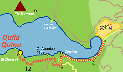
Just straight on, you will find an informative board explaining the services of the area (an organized campsite with a restaurant, a wild campsite, daytime recreation area, and the pier with a snack bar, toilets and rental of water sport activities). Quila Quina is a three-kilometre peninsula, which you can visit by car or walking if you do not have physical problems. The best way to enjoy it is walking, so we suggest to leave your car parked at the dock and seek for adventure.
Walking through the forest of Oak trees
Facing the lake turn left. First you can stop for a while in Cerro Abanico viewpoint. An information board will let you understand the formation of this particular solid rocks and local geology aspects.
The rural school of the Mapuche community (learning period September / May), La Puntilla beach, Retama and Oak trees, will be present along the way until the entrance to the natural trail "El Cipresal" (half-hour journey, 400 metres distant) where you will get to know the importance of one of the three conifers of Lanín National Park.
At the end, you will see the bridge over the Arroyo Grande (Big Stream) and the way leading towards the camping areas, and the rest of the residents' houses (consider it as an "Extra" stretch that will take an hour walk, ask for information about how to arrive at the campsites).
You can start the return from there taking the way to the left. During the tour you will see some of the residential houses typical of the village, the Park Ranger's House, and lots of Alamo trees along the way, to get back into the lake shore again after approximately 700 metres.
Take the chance to regain breath looking at the crafts from the stalls located on the pier, where you'll find -in addition to the classic wooden spoons- original products such as fruit for infusion teas, silverware and even handmade knives made of deer antlers.
You can forget about the world sitting on the sand of the wide beach, and after swimming in the water, you can visit the source of the naturally carbonated mineral water, an interesting geological phenomenon that is complemented with new views of the city and the lake.
Travel agencies offering the ride
Cnel. Díaz 751 (Centric) (02972) 428876
San Martín 437 - Loc. 3 (Centric) (02972) 425808 | (02944) 15618875
Villegas 698 Loc. 5 y 10 (Centric) (02972) 425140 | 429570
San Martín 836 2A (Centric) (02972) 427550

Office: Secretaría de Turismo - Av. San Martín y Juan Manuel de Rosas
Opening hours: 7:00hs a 14:00hs
Phone: 02972-425500
 Back to: Outdoors
 Visit also:
Thermal Springs,
Seven Lakes Area,
Paso Córdoba Area,
Lanín - Tromen Area,
Lolog Area,
Central and Vegas Areas
