It consists in a unique journey across the the lands of a Mapuche community. After a long ascent and a steep slope down, you will arrive at a residential village and one of the best beaches of the area.
Duration: One day
Distance: 18 kms
Enabled: Summer, Autumn, Spring
Description tour: Quila Quina
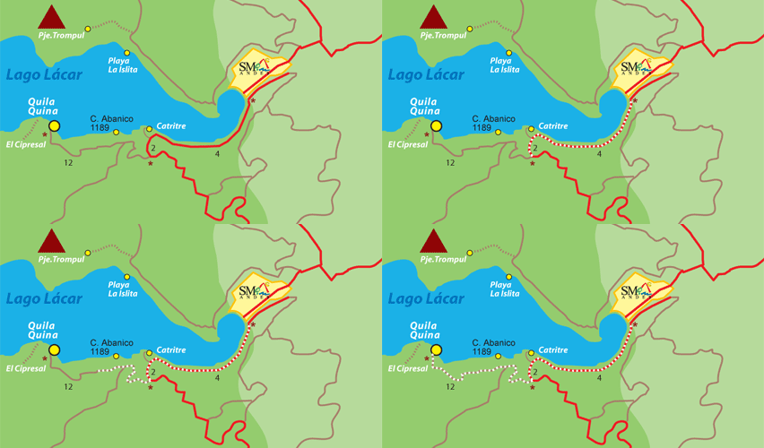
The circuit starts taking the National Road Nº 234 "of the Seven Lakes" which borders the Lácar Lake. The road is paved and you will face up and down slopes along the way.
On the left you will see a forest of Cypress trees and on the right the lake. Across the lake there is the "Cañadón de Pampa de Trompul", part of Curruhuinca hill and Bandurrias viewpoint, Trompul and Sábana hills with rounded summits formed by glacier erosion which originated the lake, of 81 km2 and 277 metres deep.
Five kilometres on the right appears the detour to Catritre Beach. A demanding ascent of one kilometre begins, until you reach the way to Quila Quina also on the right.
The way to Quila Quina
The detour to Quila Quina is not paved, a short descent begins until the bridge over Pil Pil stream, a good place to stop and rest for a while.
From here on, it starts a long and difficult ascent behind Abanico hill which is characterized by the beauty of the landscape and the presence of isolated homes of the Curruhuinca Mapuche community.
You will have to face a six kilometre ascent with three very steep slopes, until reaching a Mallín area (a low esaily flooded area, where there are tender grasses), known as "Pampa del Pino" due to the presence of an isolated Araucaria tree hidden among the forest of Ñires.
Here you will find the access to the wild campsite Tren Tren which is in charge of members of the Curruhuinca Mapuche community. Opposite you can see the Curruhuinca Volcano, and there are only six metres left to start the descent to the village.
After going past this part of the circuit you will arrive at a panoramic point from where you can enjoy an extraordinary view of Lácar Lake. A few metres further, among the trees on the right, you will see Quila Quina's peninsula, the pier, the beaches and gardens.
In the final stretch you will find a privileged viewpoint. The way is full of bends until you reach the entrance to the trail that leads to Arroyo Grande Cascade. As it is located on lands of the Mapuche community, visitors must pay a $ 3 access and a local guide will accompany you in a highly recommended 500 metre hike.
Villa Quila Quina
Back on the road, you will reach the pier "Don Bruno" and a spectacular white sandy beach, a coffe shop and toilets. Going on to the left you will see the Abanico viewpoint, the rural school and La Puntilla, a very nice beach. Further on you will find the entrance to the interpretive trail called "El Cipresal".
At the end of the circuit a bridge over the Arroyo Grende (Big Stream) leads to the campsites area and to the Mapuche community. Turning left again, before crossing the bridge, you will reach the way that leads to San Martín de los Andes to start the bike ride.
You have the option to return by ship from the pier at the port "Don Bruno", where boats depart daily to the city during summer.

Office: Secretaría de Turismo - Av. San Martín y Juan Manuel de Rosas
Opening hours: 7:00hs a 14:00hs
Phone: 02972-425500
 Back to: Sports and Adventure
 Visit also:
Trekking,
Meetings and Events,
Horseback_Riding,
Mountaineering
