Lanin volcano's summit is a challenge, its eternal snow on top dominates the landscape, and makes reaching the summit an unforgettable adventure.
Duration: More than a day
Distance: 100 kms
Enabled: Summer, Autumn, Spring
Description tour: Lanín volcano ascent
Northern or Normal Road
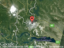
To reach the road, you must travel along the National Road Nº 234 to the town of Junín de los Andes, and there you should take the Provincial Road to Paso Tromen, 110 kilometres far from San Martín de los Andes.
Five kilometres from the town of Junín de los Andes, after crossing the bridge over Chimehuin River, you will find on the left the Provincial Road Nº 23, the first 30 kilometres to the Malleo River are paved. Just when you cross the bridge you will see on the left the Provincial Road Nº 60 which goes along the coast of the river.
This road is not paved, you will see a steppe geography until you enter the National Park, where a forest of Araucaria trees will give visitors a picturesque welcome.
Approximately five kilometres further there is the services area, with a National Gendarmerie building, the Park Ranger's House and Lanín National Park information office.
It is recommended to arrive early so as to enjoy the day and to have enough time for the climbing. The Park Ranger will check the equipment, and after this the journey to the volcano starts, which will be present on the left.
Venturing on the volcano
A vehicular track, that starts behind the Gendarmerie building, going through a forest of Lenga trees will help you avoid a forty minute walk to the base of the volcano.
Once there you start to walk towards the so-called Espina de Pescado, a glacial moraine that forms a kind of rib, rising up to 2,450 metres high, where you will find the RIM shelter (Regimiento de Infantería de Montaña) with room for a dozen people.
Since approximately two years the rise along this way is closed because of collapse. So once you start the climb, you should take your right towards the "Camino de Mulas" which leads to the BIM shelter (Batallón de Infantería de Montaña) in about four or five hours, and from there you should continue an hour and a half until the CAJA shelter (Club Andino Junín de los Andes).
The walk is slow, in continuous ascent. You must hydrate (it is essential to take 1 ½ litres of water per person) and regulate the effort made, by warming up the muscles to face the enormous effort that will be required. You will gain altitude quickly, and you will begin to enjoy exceptional panoramic views.
The path has got loose stones and a steep slope up which makes it difficult to face the strecht. Depending on the group, it will take approximately five hours of hiking.
Once you reach the BIM shelter (generally it is not used), the option is to continue for an hour until a marked detour, which leads to the RIM shelter on the left, and to the CAJA shelter on the right, with room for ten people. According to the assigned place, you should continue the walk, taking into account half an hour more to reach the last shelter. In this area you should be extremely cautious with the crevasses, which are located on the left between the two shelters.
As there is no water, it must be provided by heating and melting snow. You should make sure not to leave trash scattered and rest properly so as to wake up early before sunrise to start the ascent to the summit.
Summit on the Lanín Volcano
The second day is the key to reach the summit. You must start very early (maximum 6 am) since the snow during that time is tough and using crampons will help you walk firmly on it.
During the ascent, you should use the tip of the crampons and then the heels. Using the alpenstocks, the landscape is the best incentive so as to keep on making the effort.
The journey is difficult, it takes 6/7 hours to climb the steep slopes. It is essential lo take a warm jacket, enough water (1.5 litres per person), lips and skin sunblock protection, a windproof jacket, gloves, ski goggles or sun glasses, a hat, a pair of snow pants and energy food. The rest of the equipment will be left in the shelters.
You should use the pickaxe for security to prevent falling down. In most cases there won't be out of control fallings, but the terrain changes so you must be very careful and cautious. Many people return practicing the famous technique, sitting down and sliding on the snow. This can be very dangerous and is not recommended to do it.
Being on the summit is magical. In the distance you will see the Cordón de Fuego del Pacífico displaying an unforgettable view of all the volcanoes in the region. You will also be able to enjoy beautiful lakes and Nature in all its splendor. A fabulous 360 view will astonish you, and after taking pictures with your arms up, you will then start the return.
The descent is also exhausting, and you should rest in the shelter's area as well, then you will be able to continue the return to the base. Some may choose to stay overnight in the shelter again, but you should have to calculate a three hour hike from the summit to the shelter, and three more hours to reach the base. In this way you can descend in one day, dividing the descent in two stretches.
Travel agencies offering the ride
Av. Gral. San Martin 386 (Centric) (02972) 427877 | 427698 int.124
San Martín 437 - Loc. 3 (Centric) (02972) 425808 | (02944) 15618875

Office: Secretaría de Turismo - Av. San Martín y Juan Manuel de Rosas
Opening hours: 7:00hs a 14:00hs
Phone: 02972-425500
 Back to: Sports and Adventure
 Visit also:
Mountain bike,
Trekking,
Meetings and Events,
Horseback_Riding


